Orienteering maps are drawn using magnetic north and are printed in up to five standard colours.
- Black is used for most man-made
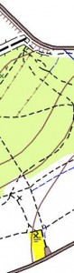 features such as buildings and rock features such as cliffs, crags and boulders
 - Brown is used to show landform, including contour lines, gullies, pits and knolls.
- Blue is used for water features such as lakes, ponds, marshes and streams
- White and Green are used to depict the density of woodland and the extent to which it impedes progress.
- Yellow is used for unwooded areas.
Combinations of yellow and green show other types of terrain which will be explained in the legend.